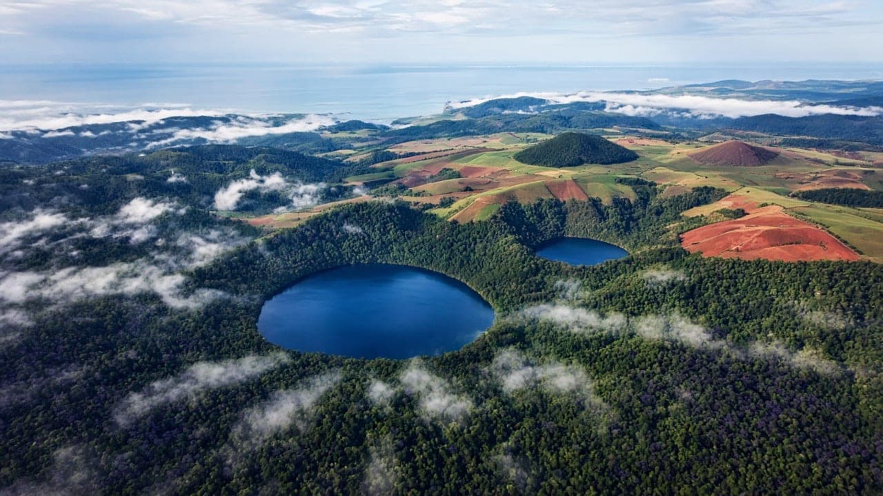
The Atherton Tableland is known for sitting above the Cairns coast: a volcanic plateau of crater lakes, farmed red soil, rainforest remnants and nights that are cooler than the sugar-and-salt air at sea level. That altitude is the point. Visitors who treat the highlands as a longer version of a Cairns beach day miss the reason to climb.
What the Tableland is for
Give the plateau its own night if you can. The lakes occupy old maars and volcanic country; walking around them is a different temperature and a different soundtrack from a lagoon pool. Towns on the Tableland are service towns for farms as much as they are visitor stops. Roads climb, mist sits, and rain can be local when the coast looks clear.
The Wet Tropics World Heritage Area wraps much of this landscape. That listing is about the rainforest’s evolutionary story, not about a theme. Stay on formed tracks, treat cassowary country as a driving caution, and read the managing authority for seasonal closures. We will not invent waterfall flow or swimming safety.
Wet and dry, not summer and winter
Far North Queensland runs on a wet season and a dry season. The wet, roughly November to April, brings heat, humidity and serious rain events on the coast, with the Tableland still wet but often less oppressive at night. The dry, roughly May to October, is the classic visitor window: lower humidity, clearer driving, cooler nights on the plateau. Neither season is “closed”. Both change which roads, creeks and views you should count on.
If your week also includes the reef, the Daintree or Port Douglas, plan the Tableland as the cool pause rather than as a driving punishment between two humid coasts.
Pairings that respect the map
Cairns beaches and the northern beaches corridor are a different guide. Port Douglas is a coastal town with a mountain behind it. Mossman, the Daintree and Cape Tribulation are rainforest-to-reef road country with wet-season constraints. The Tableland is the inland plateau. You can see more than one of these in a week. You cannot see all of them well in a weekend.
Practical notes
The climb from Cairns is short on a map and slow in a tourist-loaded car. Allow the afternoon. Fuel and food are available in tableland towns; do not treat every lookout as a kiosk. Heritage tour names from older posts on this domain are unverified historical listings. Confirm park conditions locally.
Farms, lakes and rainforest remnants
The Tableland is working country. Expect cattle, crops and service towns, then a crater lake that goes quiet ten minutes from a main street. That mix is the character. It is also why a “village boutique” fantasy can miss the place. Eat where the town eats, walk the formed lake circuits, and treat lookouts as weather-dependent.
Crater lakes occupy volcanic country. Swimming rules, if any, belong to the land manager and can change with algae, rainfall and season. We will not invent a swimming ranking. Rainforest remnants and planted windbreaks sit beside each other; both are part of how the plateau looks from the air.
Getting up and getting around
The range road is the experience as much as the destination. If you are prone to motion sickness, sit accordingly. If you are driving, keep the usual tropical cautions: wet bitumen, roaming wildlife at dusk, and rental-car rules you actually read. Public transport exists in a limited form; most visitors still treat the plateau as a self-drive or a guided day. We mention both without preferring a company.
What to read next
The dedicated Atherton Tableland guide, Cairns and beaches, Port Douglas, Mossman and the Daintree, and island gateways. The highlands hub is the inland keystone of that set.
What this hub will not do
It will not tell you which waterfall is “best”. Flow changes with rain. It will not time a cassowary. It will not price a reef boat that leaves from a different town. Those sentences belong to operators and rangers. Our sentence is: climb for the night air, walk formed tracks, and let the plateau be working country.
If you only have a day from a cruise or a connection, choose one lake circuit and one town street. That is a better Tableland day than a loop that photographs five lookouts and remembers none.
A tableland overnight, step by step
Arrive with enough light to buy food in a town, not at a lookout. Walk a lake circuit while the air is still warm. Eat where the town is actually eating. Sleep with a window that can close against mist. In the morning the plateau is often clearer than the coast; that is a gift, not a guarantee. Leave by a different road if the map offers one, so the range is not only a tunnel of trees you already saw.
Wet-season visitors should treat unsealed spurs as optional. Dry-season visitors should still carry water. Everyone should drive as if a cassowary or a cattle truck might be around a hedged corner, because both exist in this working landscape.
Reading the Wet Tropics without turning it into a slogan
World Heritage here is a scientific and cultural fact about rainforest that survived, not a watermark to put on a selfie. The rules — stay on tracks, take rubbish, watch the weather — are how the place remains itself. Rangers and Traditional Owners have more authority than a travel journal. We point at that hierarchy on purpose.